Hydrological Validation
The aim of the Hydrological Validation Programme is to independently evaluate the benefits of the novel H SAF satellite-derived data for practical hydrological applications. The H SAF concept emerged from the needs of the hydrological community, and its objective is the development and operational delivery of satellite products that can be utilised by National Hydrological Services and water management institutions. The H SAF Hydrological Programme is focused on the assessment of H SAF products through hydro-validation, which involves evaluating products from a hydrological perspective.
The purpose of the Hydrological Validation Programme is to assess the benefits of the novel H SAF satellite-derived data for practical hydrological applications and to enhance products and their usability in operational hydrology through the following activities:
- Quality assessment of products and their continuous monitoring through product validation, evaluation, and interfacing with hydrological models, conducted via impact studies;
- Development: assimilation of satellite data into hydrological models, geospatial analysis, generation of merged satellite and in-situ products (combined) that incorporate available ground information to meet the expectations of the hydrological community (e.g. requirements on accuracy and resolution), as well as testing combined products;
- Study of novel satellite products to expand, discover or gain an understanding of their applications in operational hydrology;
- Incorporation of emerging user requirements into H SAF periodic assessments;
- Promotion activities (training activities, encouraging the use of satellite products in hydrology and water management, organisation and participation in workshops, conferences, and webinars).
The main tasks carried out by the Hydrological Programme include two related, complementary, and intertwined issues:
- Impact Studies and Hydrological Validation of H SAF Products (approaches used to validate products and assess their performance from a hydrological point of view) - work package 5200.
- HSAF Product Interfacing and utilisation improvement (techniques used to enhance satellite products and make them more useful for hydrological applications) - work package 5100.
Test sites for hydrological validation are located in Belgium, Bulgaria, Finland, Germany, Italy, Poland, Slovakia, and Turkey. Hydrological validation is performed by national meteorological and hydrological services, civil protection agencies, research and academic foundations, and organisations. The hydrological models and test sites used are summarised in the following table.
|
Country (Institution) |
Hydrological model |
|
|---|---|---|
Belgium (RMI) |
SCHEME (SCHEldt and MEuse), Data-Based Mechanistic approach |
|
Bulgaria (NIMH) |
TOPKAPI, Artificial Neural Networks (ANN), Isba-Modcou model, Mike-11/NAM (Nedbør-Afstrømmings Model) |
|
Finland (FMI) |
HOPS (FMI in-house developed model) |
|
Germany (Bfg) |
HBV (Hydrologiska Byrans Vattenbalansavdelning model) |
|
Italy (CIMA) |
CONTINUUM Model |
|
Poland (IMGW) |
HBV (Hydrologiska Byrans Vattenbalansavdelning model) |
SRM (Snowmelt Runoff Model) |
Slovakia (SMHU) |
HBV (Hydrologiska Byrans Vattenbalansavdelning model) |
|
|
Turkey (ITU) Turkey (ETU) |
Artificial Neural Networks (ANN) |
|
|
SRM (Snowmelt Runoff Model), HBV (Hydrologiska Byrans Vattenbalansavdelning model) |
||
METHODOLOGY
Validation works are conducted at several related levels, including:
- standard validation of products;
- assimilation of products into rainfall-runoff models;
- analysis of the improvement of product usefulness;
- examples of product applications;
- case studies that illustrate how the products can be utilized and improved, and how they can supplement information from standard measurements and observation networks.
In addition to validation, the role of the Hydrological Programme is to demonstrate:
- how HSAF products can be used and for what purposes;
- how the usage of HSAF products can be improved;
- how HSAF products can supplement information from standard measurements and observation networks;
- case studies of their application.
The hydrological validation of H SAF products includes:
- calibration of the rainfall-runoff models (using ground data and watershed conditions and/or H SAF product data);
- model simulation using ground data (or the equivalent of validated products) as input (in the validation period);
- model simulation using satellite product as input (in the validation period);
- comparison of the obtained runoffs with the "measurements" ("observed runoff").
It should be noted that the hydrovalidation of H SAF products is based on comparisons between runoff simulated from product data and observed catchment runoff, which is considered as the "truth" in this type of analysis.
The results of the validation are presented using graphs of observed and simulated runoff (hydrographs - the most convenient method for quick visual inspection of the results) and selected statistical scores - performance measures. The following objectives are considered in product validation:
- the agreement between simulated and observed runoff;
- the agreement between the shapes of simulated and observed runoff hydrographs (including timing, rate, and volume of peak flows).
It should be emphasised that the evaluation of H SAF products is primarily conducted using hydrological models. In contrast to product validation, in which the assessment of product performance is based on a direct comparison between the product and ground-based reference measurements, hydrovalidation relies on an "indirect comparison".
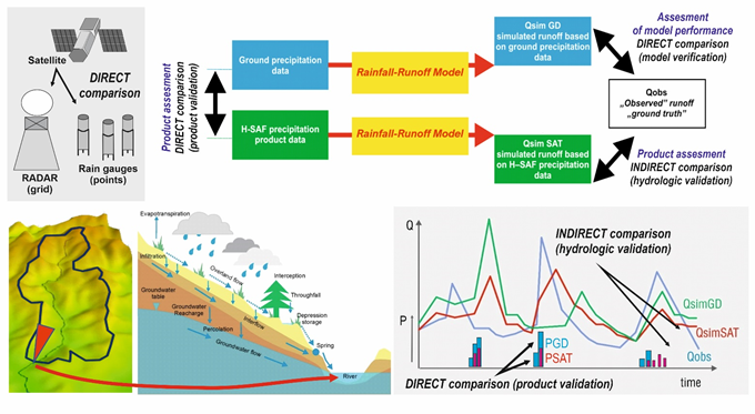
Product validation and hydrologic validation philosophy (on an example of precipitation products)
Product validation is a comparison between product values and their reference, ground data; this is a direct comparison between characteristics of the same type (e.g. estimators of precipitation amounts from HSAF products are compared with precipitation estimates from rain gauges or radar rainfall products). On the other hand, hydrological validation assesses HSAF products according to their impact on runoff simulation at the outlet of the test basin; it is based on an indirect comparison between discharges simulated using the product as model input and discharges observed at water gauge stations.
The most commonly used hydrological models accept only specific input data. From precipitation, snow cover, and soil moisture products, which are subject to hydrological validation, only precipitation products are straightforwardly accepted as time series. Snow cover and soil moisture products need to be assimilated or integrated into the models first.